NEW DELHI/DEHRADUN:
Uttarakhand chief minister Pushkar Singh Dhami is holding a cabinet meeting today and may announce some important decisions regarding subsidence-hit Joshimath town in Chamoli district.
The Uttarakhand cabinet meeting is taking place after the CM’s meeting with all stakeholders on the Joshimath land subsidence issue yesterday.
Image released by ISRO. Photo: IANS
During the meeting on Thursday, the chief minister interacted with the Army, ITBP, NDRF and scientists from various establishments engaged in landslide investigation, district administration, police and district-level officers associated with essential services at Sunil ITBP camp.
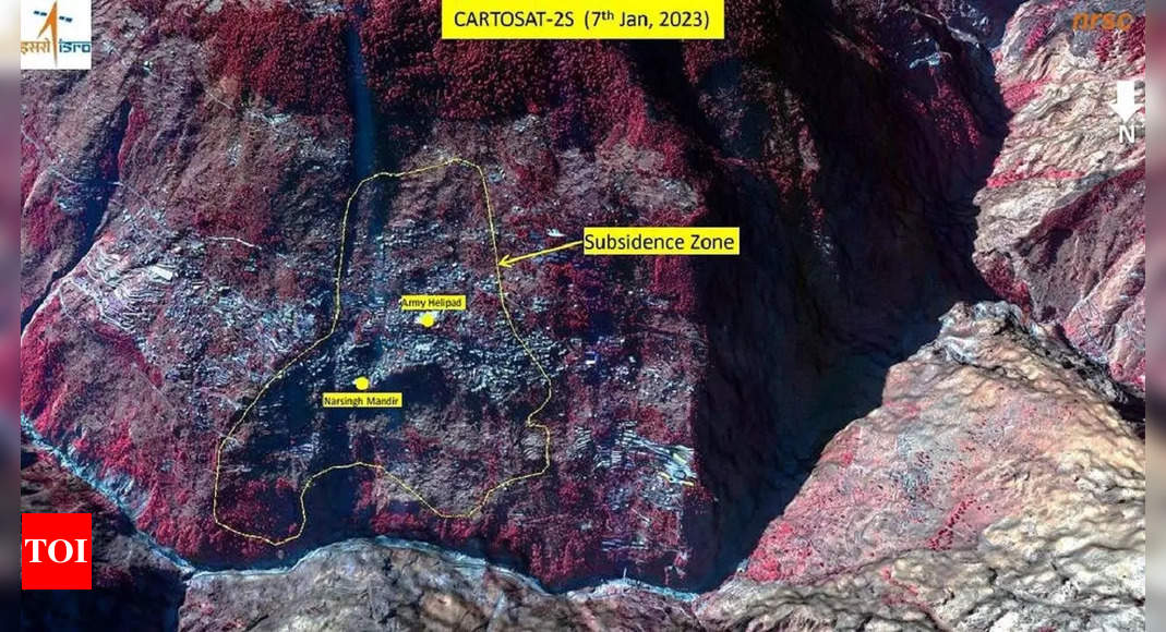
Meanwhile, the Indian Space Research Organisation’s (Isro) National Remote Sensing Centre (NRSC) in Hyderabad has released satellite images that reveal the severe land subsidence affecting the town of Joshimath. The images, taken by the Cartosat-2S satellite, show that the entire town, including the Army’s helipad and a temple, has been designated as sensitive zones.
1/20
What ISRO images tell about the sinking Joshimath
Show Captions
The National Remote Sensing Centre (NRSC) of the Indian Space Research Organisation (ISRO) has released satellite images of Joshimath and a preliminary report on land subsidence which shows that the entire town may sink.<br /><br />
The National Remote Sensing Centre (NRSC) of the Indian Space Research Organisation (ISRO) has released satellite images of Joshimath.<br /><br />
The images and preliminary report on land subsidence shows that the entire town may sink.<br /><br />
<p>The pictures are taken from the Cartosat-2S satellite.</p><p><br /><br /></p>
Hyderabad-based NRSC has released the satellite images of areas that are sinking.<br /><br />
The entire town, including the Army’s helipad and the Narasimha temple, has been marked as sensitive zone.<br /><br />
Uttarakhand government is conducting rescue operation in danger-prone areas and the people in these areas are being shifted to safer places on priority.<br /><br />
According to the report, the land subsidence was slow between April and November 2022, during which Joshimath had sunk by 8.9 cm.<br /><br />
But between December 27, 2022 and January 8, 2023, the intensity of land subsidence increased and the town sank by 5.4 cm in these 12 days.<br />
The satellite images show that the Joshimath-Auli road is also going to collapse due to the land subsidence.<br /><br />
State Disaster Response Fund (SDRF) and Nehru Institute of Mountaineering (NIM) personnel are inspecting area as Uttarakhand administration prepares for demolition of houses affected by land subsidence.<br /><br />
CM Pushkar Singh Dhami said that a committee has been formed under the district magistrate of Chamoli to “decide the final compensation amount.<br /><br />
The Uttarkhand government on Wednesday announced Rs 1.5 lakh interim relief to affected families who have been shifted to safer locations.<br /><br />
Dhami also met with scientists from various institutions and directed them to do the work of rapid assessment of Joshimath on a war footing.<br /><br />
The idea is to first identify where the landscape is facing the problem. Then, we can find ways to solve it, said Dr Swapnamita Choudhury from Wadia Institute of Himalayan Geology.<br /><br />
Another scientist said that the the slope is shifting… So now we have to identify which surface is moving. “Only then we can provide a permanent solution.”<br /><br />
CM Dhami said that they will try to give the best possible compensation package to and to affected families.<br /><br />
He also assured that they will conduct the Auli winter games (next month) and also the Char Dham yatra successfully despite the challenge posed by the present crisis<br /><br />
Municipal corporation employees prepare firewood for shelter houses set up for residents affected by the land subsidence.<br /><br />
Meanwhile, Uttarakhand HC heard a PIL and instructed the government to constitute a committee of independent experts to study the matter and present its report to the court in a sealed envelope within two months.<br /><br />
The preliminary report from Isro states that the land subsidence was slow between April and November 2022, during which time the town sank by 8.9cm.

Image released by ISRO. Photo: IANS
However, between December 27, 2022 and January 8, 2023, the intensity of land subsidence increased dramatically, causing the town to sink by an additional 5.4 cm in just 12 days.
The Uttarakhand government is already conducting rescue operations in danger-prone areas and relocating residents to safer locations as a priority. The satellite images also indicate that the Joshimath-Auli road is at risk of collapse due to the land subsidence.
1/20
These photos capture the anger and helplessness in Joshimath
Show Captions
<p>A woman sits beside a cracked wall of her house at Joshimath in Chamoli</p>
<p>Locals protest against the demolision of the unsafe hotels and houses after cracks appeared at the landslide affected area of Joshimath</p>
<p>As many as 131 families have been shifted to the temporary relief centres so far with 37 more evacuated on Tuesday</p>
<p>A resident gets emotional prior to leaving her house that have been marked unsafe by the district administration</p>
<p>Women break down prior to leaving their home that have been marked unsafe by the district administration</p>
<p>People affected by the gradual sinking of Joshimath rest at a shelter house after cracks appeared in their houses</p>
<p>At least 86 houses in the area have been demarcated as an unsafe zone</p>
<p>People shift their belongings after their houses were declared to be in the unsafe zones in view of the continued land subsidence</p>
<p>Hotels lean into each other as a result of the continued land subsidence</p>
<p>Located 82km southwest of Joshimath in Chamoli district, parts of Karnaprayag — one of the ‘panch prayags’ of Alaknanda, situated at the confluence of the river and Pindar — are “sinking” too</p>
<p>Repair work under way following collapse of a wall in Joshimath area</p>
<p>Cracks appear on stairs in Joshimath area of Chamoli district. The town has been declared a disaster-prone area after large cracks appeared in homes and on roads</p>
<p>Cracks appear on the road as the result of continued land subsidence in Joshimath</p>
<p>Locals outside the hotel where cracks have appeared as a result of continuous land subsidence</p>
<p>A man walks on a pathway of a building damaged due to land subsidence in Joshimath</p>
<p>Workers disconnect the electricity connection at the landslide affected area of Joshimath</p>
<p>SDRF and Nehru Institute of Mountaineering personnel inspect an area as Uttarakhand administration prepares for demolition of hotels and houses severely affected by land subsidence</p>
<p>Stairs of a building are severely affected due to cracks</p>
<p>Locals protest against the government’s decision to demolish the hotels after cracks appeared at the landslide affected area of Joshimath</p>
Watch What satellite images reveal: All of Joshimath may sink!
Source link